The University of Nottingham
 Exchange online
Research Exchange
What lies beneath? New survey technique offers detailed picture of our changing landscape

A new surveying technique developed at The University of Nottingham is giving geologists their first detailed picture of how ground movement associated with historical mining is changing the face of our landscape.
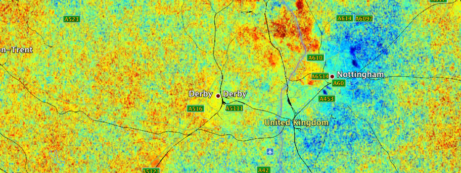
The new development by engineers at the University has revealed a more complete map of subsidence and uplift caused by the settlement of old mines in the East Midlands and other areas of the country and has shown that small movements in the landscape are bound by natural fault lines and mining blocks.
It appears to support concerns that movement associated with historical mining is continuing far longer than previously anticipated.
The research has been led by Dr Andrew Sowter in the University’s Department of Civil Engineering. He said: “This method allows us to measure patterns of slow millimetre-scale movement across large regions of the landscape and, in the UK, almost everywhere we look is dominated by our industrial past. Large tracts of our land, including parts of our cities, towns and infrastructure as well as agricultural and woodland areas, are steadily creeping upwards over mines that were closed decades ago.”
The new development builds on existing technology that allows engineers to use satellite radar technology to measure points on the landscape over a length of time to assess whether they are moving up (uplifting) or sinking down (subsiding).
Previously, this has relied on using fixed, unchanging objects like buildings that can be accurately re-measured and compared against previous measurements time after time. However, the technique has not been practical for use in the rural landscape meaning that geologists could only get half the picture.
Now, Dr Sowter has developed a technique called the Intermittent Small Baseline Subset (ISBAS) method which adapts the same technology and extends it to rural areas by taking stacks of these radar images and identifying those more transient points in the rural landscape against which changes over time are able to be measured.
The technique is now being used by the British Geological Survey (BGS), based in Keyworth in Nottinghamshire, which is the world’s oldest national geological survey providing expert services and impartial advice on all areas of geosciences for both the public and private sectors.
Principal geologist at the BGS Poul Strange said: “This new technique is going to allow us to refine our geological maps. Previously when surveying rural areas we were almost guessing and the final result was more of an interpretation. Now we are able to produce maps that far more accurately reflect what is happening with the geology below the surface and enable us to predict any potential risks posed by ground movement.
“Rural areas are particularly important because we need to know what is happening with the geology there and how movement or natural fault lines may affect future developments such as new housing or high speed rail links.”
The technique will assist BGS in the work it is doing looking at potential ground movement in former mining areas of South Derbyshire, Nottinghamshire and Leicestershire where most mines closed no later than the early 90s.
The BGS has so far recorded geological evidence that movement in areas where deep coal mining has been in operation historically actually continues for up to 11 years, far more than any previous estimate such as the six-year limit set by the Subsidence Act of 1991.
They believe the problem may be caused by ground water, which would have been pumped out while the mines were open, seeping back into the disused pits and causing a ‘bounce back’ effect on the surrounding landscape. However, they estimate that this uplift is only likely to offer around a 4% recovery on where the landscape would have been before mining began.
In particular, they have been using the new technique to explore the rural areas surrounding locations like Swadlincote in Derbyshire and Oakthorpe near Measham in Leicestershire which have a long-standing history of problems with mining-related subsidence.
They are able to see how this movement is interacting with natural fault lines, which could potentially cause other seismic activity such as the Market Rasen earthquake of 2008, which measured 5.2 on the Richter Scale and was felt as far away as Wales, Scotland and London.
The research could also be of vital significance in assessing future issues with subsidence and uplift connected with other types of activity such as fracking, where geological shale rocks are drilled and injected with fluid to encourage them to fracture and release natural gases.
Dr Sowter has previously spent time working at The University of Nottingham China Ningbo, where his research centred on China’s ‘sinking cities’ problem, where some of the country’s most densely populated communities, such as Shanghai, are sinking under the weight of towering skyscrapers.
Funded by the National Natural Science Foundation of China, the work aimed to develop techniques to help Chinese authorities identify with far greater accuracy which areas are moving and by how much.
Leave a Reply
Other News

Top prize for quantum physicist
A University of Nottingham physicist has won a prestigious medal from the Institute of Physics for […]

Zero carbon HOUSE designed and built by students comes home
Design and construct a low cost, zero carbon, family starter home, transport it to Spain, build […]